Mission Bay: Difference between revisions
m (New page: Image:norbeach$san-francisco-map-1874.jpg '''An 1874 artist's bird's-eye view of SF shows Mission Bay on the left.''' ''Image: Bancroft Library, Berkeley, CA'') |
(map is actually a Currier and Ives depiction from 1878, changed date and source, since the Rumsey map collection has a public domain version available for download.) |
||
| (3 intermediate revisions by 2 users not shown) | |||
| Line 1: | Line 1: | ||
[[Category:Neighborhood/Geography]] | |||
[[Image:norbeach$san-francisco-map-1874.jpg]] | [[Image:norbeach$san-francisco-map-1874.jpg]] | ||
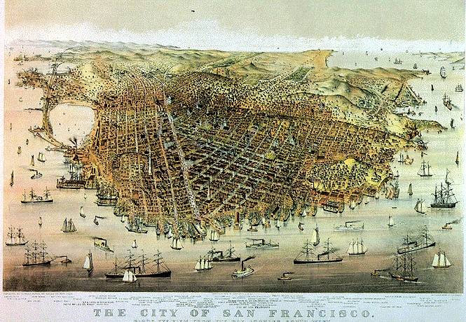
'''An | '''An 1878 Charles Parsons bird's-eye view of SF shows Mission Bay on the left almost entirely closed off from the San Francisco Bay by the Long Bridge.''' | ||
''Image: | ''Image: [https://www.davidrumsey.com/luna/servlet/detail/RUMSEY~8~1~24614~900100:San-Francisco-Birds-eye-view-?sort=Pub_List_No_InitialSort%2CPub_Date%2CPub_List_No%2CSeries_No&qvq=q:charles%2Bparsons%2B1878;sort:Pub_List_No_InitialSort%2CPub_Date%2CPub_List_No%2CSeries_No;lc:RUMSEY~8~1&mi=0&trs=1 David Rumsey Collection]'' | ||
Latest revision as of 16:06, 13 February 2018
An 1878 Charles Parsons bird's-eye view of SF shows Mission Bay on the left almost entirely closed off from the San Francisco Bay by the Long Bridge.
Image: David Rumsey Collection
Pages in category "Mission Bay"
The following 49 pages are in this category, out of 49 total.
1
L
M
- McCovey Cove
- Mexican Land Claims—The U.S. Land Commission and The Burden of Proof, 1851-1854
- MISSION BAY
- Neighborhood/Geography
- Mission Bay Gazeteer of Historic Places
- Mission Bay Tidelands Controversy, 1868-1879
- Mission Creek
- Mission Creek 1920s
- Mission Creek 1938 aerial
- Mission Creek Banana Boats
- Mission Creek in the 1980s Before Redevelopment
- Mission Creek Wildlife
- Mission Plank Road
- Mission Rock
- More Than Just Baseball—OctoberTogether

