San Francisco is Sinking: Difference between revisions
(Created page with "'''<font face = Papyrus> <font color = maroon> <font size = 4>Historical Essay</font></font> </font>''' ''by Chris Carlsson, originally published on sf.streetsblog.org in 200...") |
No edit summary |
||
| Line 82: | Line 82: | ||
[[Image:Downtwn1$market-st-1851.jpg]] | [[Image:Downtwn1$market-st-1851.jpg]] | ||
'''Market and Powell are added to this 1851 photo. This view is from apx. 2nd and Folsom. Note the very tall sand dunes to the left and in the distance. This is today’s rather flat South of Market area!''' | |||
''Photo: OpenSFHistory / wnp71.0522'' | |||
''Photo: | |||
Facing ongoing subsidence, rising oceans, and eventual earthquakes, San Franciscans might do well to consider how to cope with a city that is sinking, as the natural landscape beneath resumes its historic trajectory–interrupted, after all, for only about 100 years. A very short time indeed! | Facing ongoing subsidence, rising oceans, and eventual earthquakes, San Franciscans might do well to consider how to cope with a city that is sinking, as the natural landscape beneath resumes its historic trajectory–interrupted, after all, for only about 100 years. A very short time indeed! | ||
[[category:SOMA]] [[category:Water]] [[category:Ecology]] [[category:2000s]] [[category:Roads]] [[category:Buildings]] | [[category:SOMA]] [[category:Water]] [[category:Ecology]] [[category:2000s]] [[category:Roads]] [[category:Buildings]] | ||
Latest revision as of 12:08, 28 September 2021
Historical Essay
by Chris Carlsson, originally published on sf.streetsblog.org in 2009
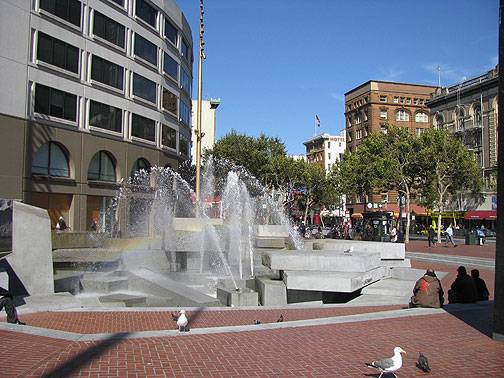
UN Plaza, Market and 7th, the waters from the subterranean "Mighty Hayes River"!!
Photo: Chris Carlsson
Famously, we live on a crack in the earth. The San Andreas Fault gets most of our attention, followed not too far behind these days by the equally ominous Hayward Fault. A major earthquake on either of these could alter local landscapes forever, and will certainly damage or destroy freeways, bridges, and the water system. That’s one of our catastrophes waiting in the wings, and it’s good think about preparing for such eventualities.
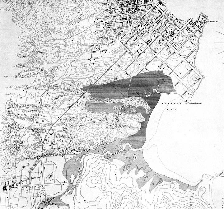
Less obvious, but just as much a part of our local natural landscape (largely obscured by asphalt and buildings), are the old waterways on which the city is built. The evidence for these underground waterways is in plain view as well as being represented in various public documents. Joel Pomerantz wrote "San Francisco’s Clean Little Secret" a few years ago (first appearing in a book I edited "The Political Edge" City Lights: 2004) wherein he found in SF Water Dept. official reports the saga of the "Mighty Hayes River." Starting deep underground somewhere near Lone Mountain, the subterranean river flows southeast under Civic Center, and as you can see on this map, once surfaced around 7th and Mission.
1852 U.S. Coastal Survey Map of San Francisco, from Yerba Buena Cove at upper right to Mission Bay on right. Mission Plank Road is the long diagonal that clips the edge of the swampy wetlands at apx. today’s 7th and Mission.
Map courtesy David Rumsey Map Collection
According to Joel:
"With a hydromorphology not unlike Florida’s everglades, [the Hayes River] broadsides Market Street, encountering a long concrete subway tunnel that interrupts its gait. So copious are the waters of the Hayes that, to protect their investment from damage, BART runs “de-watering” pumps day and night in the Powell Street BART station. Removing, each week, 2.5 million gallons of tested, high-quality, potable groundwater (into the sewer!) the transit agency keeps the Hayes from flooding the tracks."
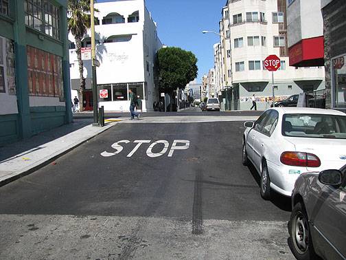
It’s not far to the obvious subsidence at Natoma Alley just west of 7th where the street level falls at least 5 feet from the grade on the larger 7th Street.
Natoma Street, easterly, just west of 7th.
Photo: Chris Carlsson
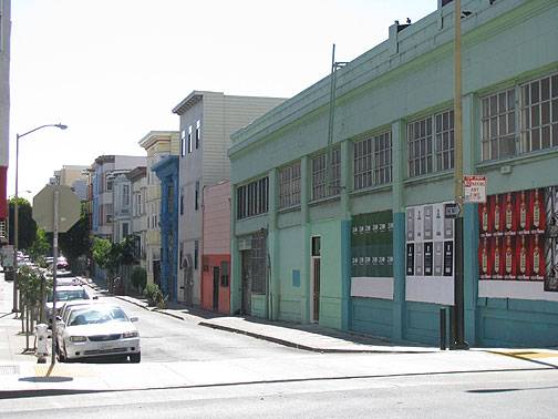
Same intersection of Natoma and 7th looking from east to west.
Photo: Chris Carlsson
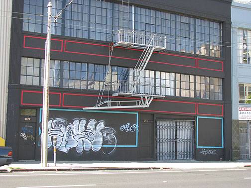
On Howard Street, a hundred or so feet south, two warehouses have been slowly sinking into the underlying marsh. Several efforts to cosmetically disguise what’s happening have been implemented in recent years, but this latest version, painting the horizontal red boxes, seems to emphasize the effect.
Sinking warehouses on Howard Street opposite Langton Alley. Note the red horizontal boxes painted on the front of the darker warehouse… the second one noticeably angles downward. Note too how the stripes in the road indicate the dip.
Photo: Chris Carlsson
Same warehouse straight on.
Photo: Chris Carlsson
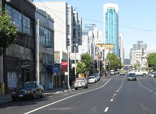
There are a few other spots near here, all in the former wetlands, where you can see the sinking.
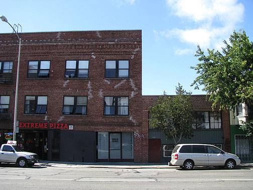
Extreme Pizza brick building on Folsom near Russ Street. Cracks in the facade have been patched, but there’s no denying the building is slumping to the right, sinking into the marsh!
Photo: Chris Carlsson
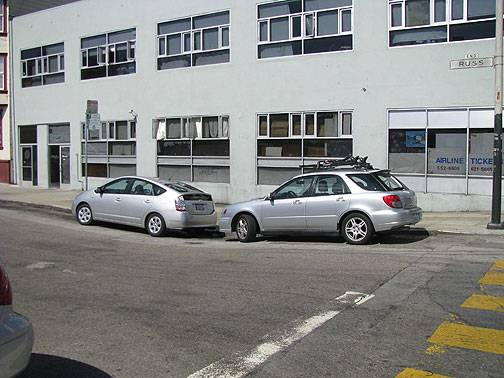
Just around the corner from the Pizza brick building, on Russ Alley, these cars highlight a sinking spot.
Photo: Chris Carlsson
These buildings on Folsom between 6th and 5th show signs of subsidence too. The older ones are tipping back from the street, as the rear of the structures are sinking. Before a lot of new lofts were built in the 1990s in this area, many old warehouses were obviously sinking after the 1989 earthquake, on Folsom, Harrison and the alleys in between.
Photo: Chris Carlsson
In an 1878 history by J.S. Hittell (History of the City of San Francisco and Incidentally of the State of California, cited in Nancy Olmsted’s Vanished Waters: A History of San Francisco’s Mission Bay. San Francisco: Mission Creek Conservancy, 1986) the 80-100 foot deep marshes presented a significant barrier to surface transportation. The first road to cross them was the Mission Plank tollroad, but there were engineering problems right away.
“Mission Bay’s slender connection to Gold Rush San Francisco is the Mission Plank Road. (today’s Mission Street), which opened as a toll road in 1851. Its three-and-a-quarter-mile length ran into trouble for the contractors where it crossed the line of Seventh Street (shown but not named on the map).
Here they projected a bridge built on pilings, “but that plan had to be abandoned, to the astonishment and dismay of the contractor; the first pile, forty feet long, at the first blow of the pile driver sank out of sight, indicating that there was no bottom within forty feet to support a bridge. One pile having disappeared, the contractor hoisted another immediately over the first and in two blows drove the second down beyond the reach of the hammer… there was no foundation within eighty feet… pilings were abandoned, and cribs of logs were laid upon the turf so as to get a wider base than offered by piles. The bridge made thus always shook when crossed by heavy teams and gradually settled till it was in the middle about five feet below the original level… the cost of the road was ninety-six thousand dollars, about thirty thousand dollars per mile… the plank road company obtained another franchise for a road on Folsom Street… in 1854 a high tide overflowed the [Folsom] road between Fourth and Fifth and floated off the planking.”
J.S. Hittell observes that, although these marshy areas were called swamps, “They seem to have been for part of their area at least, subterranean lakes from forty to eighty feet deep, covered by a crust of peat moss eight or ten feet thick… When the streets were first made, the weight of the sand pressed the peat down, so that the water stood where the surface was dry before… More than once a contractor had put on enough sand to raise the street to the official grade, and gave notice to the city engineer to inspect the work, but in the lapse of a day between notice and inspection the sand had sunk down six or eight feet… heavy sand crowded under the light peat at the sides of the street and lifted it up eight or ten feet above its original level, in muddy riddges full of hideous cracks…it was also pushed sidewise so that houses and fences built upon it were carried away from their original position and tilted up at singular angles…”
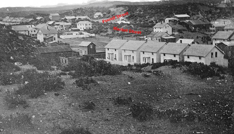
The toll road to the mission probably would have gone out Market Street instead of trying to cross these soggy swamps, but in that era tall sand hills still dominated the terrain. The relatively flat Market Street we know today was blocked by an 80-foot sandhill between Second and Third Streets… What happened to all that sand? In the period 1859 to 1873, the "steam paddy" (or giant steam shovel—it was said to do the work of twenty Irish laborers at a single stroke) took south-of-Market sand to fill Mission Bay, establishing a century-long pattern of leveling hills and using the sand, rock, and soil to fill in nearby wetlands to "make land." It wasn’t until the 1965 McAteer-Petris Act established the Bay Conservation and Development Commission that the pell-mell filling of the bay was halted.
Market and Powell are added to this 1851 photo. This view is from apx. 2nd and Folsom. Note the very tall sand dunes to the left and in the distance. This is today’s rather flat South of Market area!
Photo: OpenSFHistory / wnp71.0522
Facing ongoing subsidence, rising oceans, and eventual earthquakes, San Franciscans might do well to consider how to cope with a city that is sinking, as the natural landscape beneath resumes its historic trajectory–interrupted, after all, for only about 100 years. A very short time indeed!

