Sunset NW 1930: Difference between revisions
(added photo) |
(added photo) |
||
| Line 20: | Line 20: | ||
''Photo: OpenSFHistory.org wnp27.5515'' | ''Photo: OpenSFHistory.org wnp27.5515'' | ||
[[Image:Taraval near 33rd westerly May 11, 1920 wnp36.02276.jpg]] | |||
''''Taraval looking west near 33rd Avenue, May 11, 1920.''' | |||
''Photo: OpenSFHistoryorg wnp36.02276'' | |||
[[Sunset Houses |Prev. Document]] [[WHY INNER SUNSET COMMUNITY FOOD STORE WENT DOWN |Next Document]] | [[Sunset Houses |Prev. Document]] [[WHY INNER SUNSET COMMUNITY FOOD STORE WENT DOWN |Next Document]] | ||
[[category:Sunset]] [[category:1930s]] [[category:1940s]] [[category:transit]] | [[category:Sunset]] [[category:1920s]] [[category:1930s]] [[category:1940s]] [[category:transit]] [[category:roads]] | ||
Revision as of 18:00, 23 November 2020
Unfinished History
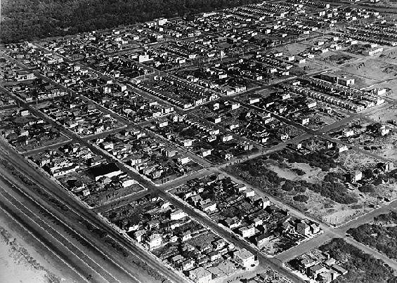
The northwest corner of the Sunset as seen in 1930.
Golden Gate Park is the dark band at upper left; the Great Highway is at the lower left. Moraga Avenue is the street in the lower right corner.
Photo: Private Collection, San Francisco, CA
N-Judah streetcar turnaround at Judah and Great Ocean Highway, 1930s.
Photo: C. R. collection
Ortega and Sunset from the air, 1941.
Photo: OpenSFHistory.org wnp27.5515
'Taraval looking west near 33rd Avenue, May 11, 1920.
Photo: OpenSFHistoryorg wnp36.02276


