Ridgway’s Rail and the Second Saving of the San Francisco Bay
Historical Essay
by Elizabeth Creely
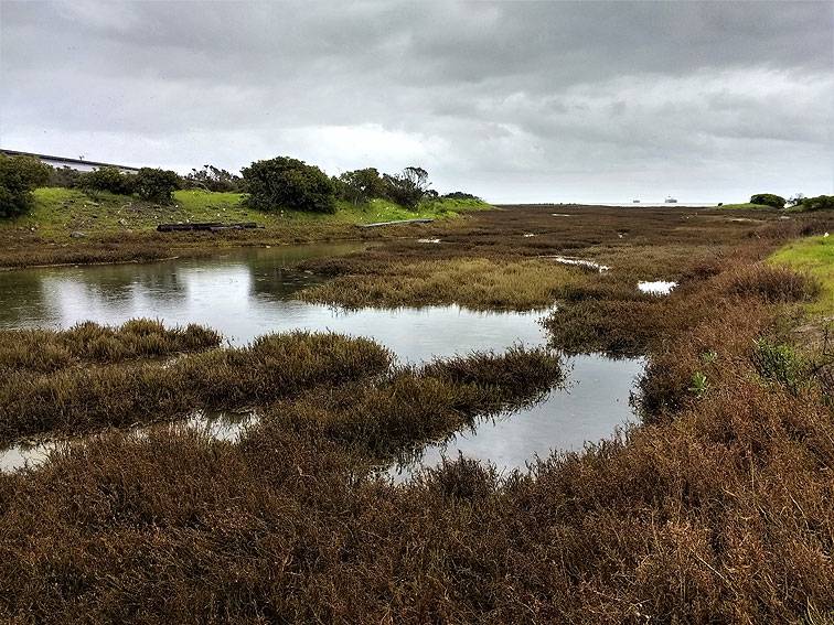
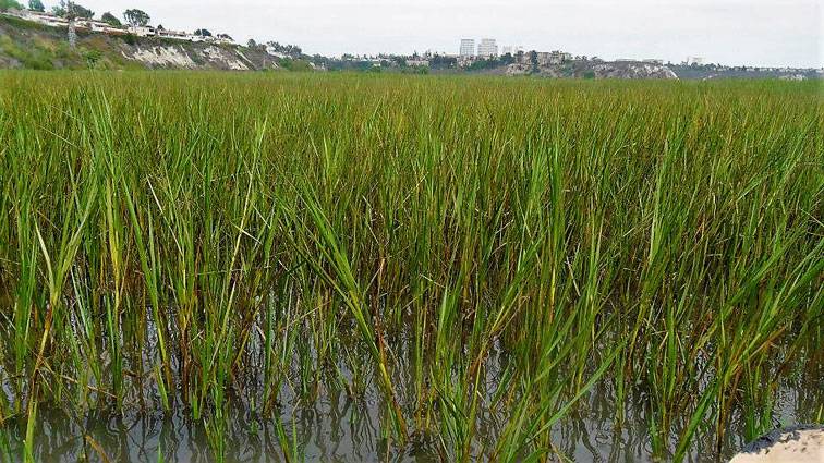
Heron's Head Park, looking easterly, February 2017.
Photo: Elizabeth Creely
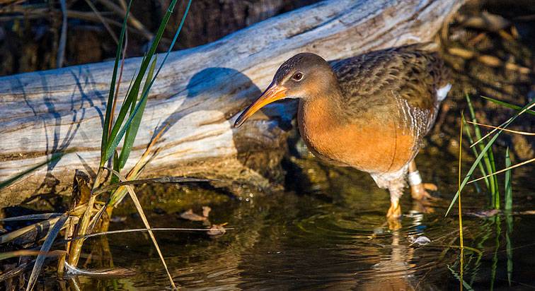
On November 4th, I walked to the Exploratorium in San Francisco: bay scientists had just released an updated report on climate change and the state of the bay, and I chose (appropriately, I thought) to walk along the Bay Trail that winds through the Embarcadero. It’s a great place to think about the past: indeed the interpretative signage encourages you to do just that. At Pier 3, the home of Hornblower Cruises, I stopped because I saw an odd-looking bird with a compact body and feathers that resembled a fine English tweed. It was gripping a mooring line with its feet, and peering into the water. Quickly, in lightning-fast movements, the bird pecked the water and pulled one miniscule fish out of the thousands that were schooling and giddy amidst all the carnage. Their thrashing bodies illuminated the water with sparks of silvery light. I walked on. Twenty minutes later, Letitia Grenier, senior scientist with the San Francisco Estuary Institute, showed one of the potential victims of rising sea levels, a marsh bird called a Ridgway’s rail. Grenier described it as one of the most endangered species in the bay. I recognized it immediately. It was the bird I’d seen minutes before.
Amelia, a captive-bred light-footed Ridgway's rail emerges from hiding at the Living Coast Discovery Center on San Diego Bay National Wildlife Refuge. Team Clapper Rail has bred and released 451 light-footed Ridgways rails since the program began in 2001.
Photo: Rinus Baak/USFWS
The sighting of the lone rail turned out to be an appropriate preface to a somber discussion of the centuries—or maybe epochs— of ecological change that climate instability will almost certainly bring. Species adaptation to climate change is something usually described rather than seen, but the rail had given me a preview of the future after the sea had risen. The rail is a reclusive bird and a picky eater, preferring to hide in cordgrass and feed on nearby mudflats. That could change along with the climate, which may turn the bird into a generalist, living in plain sight and going where the food is. The mudflats it feeds on, and the tidal marshes it nests in, are in danger of drowning. There isn’t enough sediment to keep them above the rising ocean. If these tidal sites drown—a funny turn of events for such a famously watery site—the rail’s habitat will be completely destroyed. It’s an irony not lost on the coterie of scientists who work on behalf of the bay, that sediment is yet again an issue, although not in the manner of the preceding century when it was thought that there was too much of it. There is now not enough of the stuff. The process of putting back something that once seemed plentiful is a dilemma that will call upon all the ingenuity that bay scientists and regulators can muster. The San Francisco Bay was saved once, already. Wetlands scientists estimate that they have about 15 years to save the bay one more time.
In the last century, the ocean rose almost 8 inches. By 2050, sea levels could rise as much as two feet and could rise further, up to five feet by 2100. Between now and 2050, the bay will need 1 million cubic meters of sediment a year or 35 million cubic meters of sediment total, to meet keep tidal flats and marshes—and possibly the bay floor itself—above water. By 2100, that number jumps again to 84 million cubic meters. Both these amounts are so surpassingly huge that translating them into tons yields little insight: it’s enough to say that tons and tons (and tons?) sediment needs to be found, or recovered and introduced into the tidal prism, or painstakingly hand-placed—this last tactic sounds unbelievable, but it’s actually happened—in the tidal marshes of the bay.
This work of putting back what was taken out has already begun. In 1999, 60,000 acres of tidal marsh and diked wetland were recommended for restoration, and since then, 7,000 acres have been restored. A further 28,000 acres of tidal marsh are waiting in the wings. Connectivity, space and sediment: if these elements are in place, the bay can respond to changes in climate. Take one of these powers away, and it becomes difficult for the bay to retain the full suite of services it offers to wildlife and plants. Take all three away and the idea of adaptation becomes an impossible dream. The Ridgway rail and the Mooring Line: it sounds like a latter-day Aesop tale, albeit one with an unwritten ending. The San Francisco Bay Conservation and Development Commission (BCDC) and other regulatory agencies and policy makers are writing that ending now, as fast as they can and building a new relationship with sediment. If the essence of the bay’s natural history is one of responsiveness to change,so too, must be the planning that will oversee the bay for the next century.
Nature prefers to move deliberately over many years. In the past, the bay capably handled the swings of California’s climate. Core sampling from the bay floor shows a history of constant change as the bay’s tidal marshes converted to mud flats and then changed back again, all in response to the “drivers” of bay ecology: the climate, the amount of freshwater draining from the Sierra and the ocean. Urban development changed everything. Watersheds that brought sediment into the bay were detached from the tidal regime, and other natural features that contributed to bay formation were paved over. A wetland scientist told me that we didn’t live in an area where there was a lot of wind-driven sediment. Not anymore, I wanted to say. But we used to. Consider the city, perched on the bay’s edge: under the streets of San Francisco lies much of the bay’s rightful due, sand. San Francisco’s extensive (and rare) sand dune ecology mantled the glossy maroon-colored chert rock, the dominant bedrock of the city, until the village of Yerba Buena started filling up with people who wanted paved streets to walk and trade on, and houses to live in, instead of sheltering in canvass tents hastily erected in the hollows between the towering sand dunes.
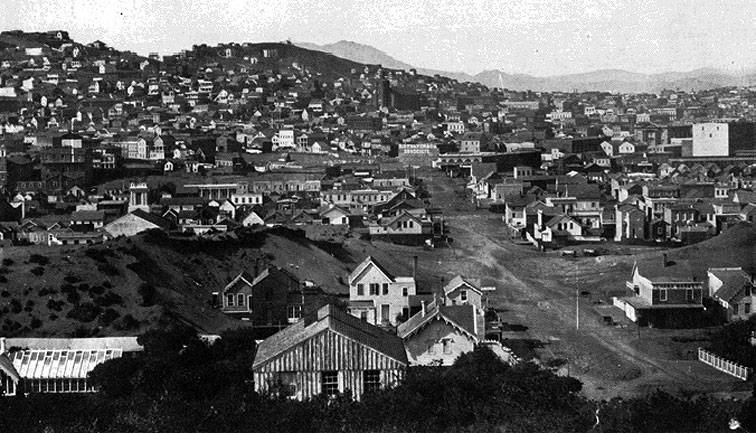
This 1856 view northward along 2nd street shows still extant large sand dunes to the west in areas that are now basically flattened and fully urbanized.
Photo: Private Collector
A United States Coast survey map from 1853 shows the lost east coast of San Francisco. Mission Creek, rendered as a tentacular waterway, is thick with tidal marshes that extend deep into what is now the inner Mission. The open lands that surround the creek are studded with sand dunes, some eighty feet high, in what would become San Francisco’s downtown and financial district. “O’Farrell’s Mountain” was a sand dune that was reportedly sixty feet high. Named after Jasper O’Farrell, the Irish-born surveyor who laid out the grid of San Francisco’s city streets, the sand dune, and others like it, was dismantled so that Union Square could be built. Sand dunes once stretched from Ocean Beach to the foot of Market Street, making the air gritty with sandstorms that whipped through the city. The only feature left from this vanished system is the wind.
Most Bay sediment comes from local bedrock. Some sediment still makes its way from the enormous granite batholith underlying the Sierra Nevada. Whatever its source, it floats in the water, until the wave patterns of the bay deposit it near the bay’s edge. Marsh vegetation grabs it and holds it; this system, repeated over and over, is how the bay built itself for thousands of years. In San Francisco, sediment tends to get characterized as the most tangible symptom of the excesses of California’s Gold Rush and the craze of hydraulic mining, which sent rivers of mud careering through the Yuba river, and into the bay, where it clouded the waters with a thick plug of earth that had been scraped off the sides of various “diggins’” with colorful names like You Bet, Dutch Flat, and Red Dog. The 1884 Sawyer ruling, which stopped hydraulic mining in the Sierra, was functionally one of the earliest measures to manage the bay, although the bay was not the focus of the ruling; aggrieved farmers were. The Sawyer decision may have halted the rapid introduction of sediment but it also ushered in an era which characterized sediment as a problem, more like MOOP—Matter Out Of Place— than a ecological resource, and it was treated that for most of the 20th century.
There is plenty of sediment, but like the wayward rail, it’s in some odd places. About 240 million cubic meters of it has been dumped off the California coast after being dredged from the central bay to provide ease of passage for the enormous ships that thread their way through the Golden Gate and into the Port of Oakland. International commerce could not do its business without the mass extraction of bay sand. Mining, which has scarred the Sierra so horribly, has taken a toll on the bottom of the bay as well: aggregate companies have taken another 2.3 million cubic meters out of the bay. Until recently private aggregate companies could get mining leases easily from the California State Lands Commission. That stopped being the case in September of 2015, when the California Coastal Commission, responding to a suit brought forward by San Francisco Baykeeper against the state, denied the private leases granted to mining concerns and classified California sand as a “public resource.”
This public resource is impounded along with the water that carries it behind California’s elaborate system of water and flood control —“It doesn’t come into the system when it’s sitting in reservoirs and dams,” a scientist observed rather plaintively to me— leaving the animals that feed, burrow and crawl in the bay mud without the means of surviving the oncoming sea. They’re completely dependent on this public resource, the stinky marsh mud and bay sand, to lead their often invisible and muddy lives which, in the aggregate, create what is called “bio-diversity”, a phrase that appears with stodgy regularity in government reports which strains towards translating the vast workings and delicately calibrated relationships between the species guilds of the bay.
In 1999, a USGS scientist named David Schoellhamer noticed that the suspended sediment concentrations in the bay had dropped. “He brought forward a survey in 2006 that said the suspended sediment load coming into the bay had dropped significantly,” Brenda Goeden, Sediment Program Manager for the BCDC told me, “and said that the system was changing, and that he didn’t expect it to come back up.” We were sitting in her office, talking over the frantic cheepings of two baby swallows that Goeden had rescued and was hand-feeding. The system Goeden was referring to has many moving parts: water is just one of them, but it’s a biggie. During the thousands of years of tidal marsh formation,a vast and informal network of water from rivers, creeks, and streams ruled California, going where it wanted to go, which—in the way of water—was always down from the mountains, and sometimes in great floods. Goeden spoke appreciatively of this chaotic process. “In a physical process world, floods are actually a good thing,” she told me. “They pick up heavy sediments—sands and muds—and push them further downstream. When you keep the water moving at a constant rate and don’t let storms create floods, the sediment isn’t moved.”
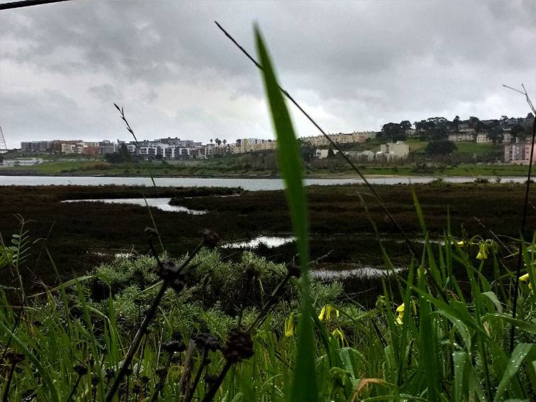
Heron's Head park, looking south towards Hunter's Point.
Photo: Elizabeth Creely
In an urbanized world however, floods are regarded as disastrous. In 1938, the Santa Ana River in Southern California overflowed its banks and flooded 68,400 acres of land, mostly the small agricultural towns of Orange, Buena Park, Fountain Valley, and Garden Grove that were scattered on the Tustin Plain. Nineteen people died. When floods kill people, dams and flood control structures get built. The wild rivers of California were channelized, and forcibly drained into the ocean. “We have very large water control structures taking water downstream out of the system,” Goeden told me.“When it does that, it takes suspended sediment with it. The other thing it does is it reduces the ability of the bay system to flood. We need stream flow to provide sediment to the bay.” Under current flood control practices, the most important contribution rivers, creeks and streams can make to the bay —other than introducing fresh water into an estuarine system that’s becoming increasingly more salty—is one they’re not allowed to make.
The task at hand, then, is to get the sediment back where it belongs, circulating in the waters in the bay. If this happens, the marshes will respond by vertically accreting, and gaining “elevation capital” and protecting not only wild, but urban habitats. Marshes are cast as the savior of cities in the upcoming climate dramas of the twenty-first century as extreme storm events increase, taking over from dams and concert culverts to provide flood control. If all goes to plan, Bay Areans will have a re-engineered tidal marsh that looks and functions more like the marshes looked back in the early nineteenth century. But there’s a lot of uncertainty that stands in the way between that vision and the reality of re-engineering a massive hydrological system. Goeden sighed and said, “Part of our challenge is that we don’t really know what the natural bay suspended sediment load is.”
Official record taking started after the Gold Rush, after the plug of hydraulic sediment entered the bay. The system that’s been around for more than 160 years is the system scientists know. “For the last ten years, we’ve started to understand the system’s changing,” Goeden told me. “We have some ideas about what it’s changing to, but we don’t really know how it’s going to play out.” Bay scientists are quick to point out that California’s climate has been stable for the past 150 years. Marshes and the people who manage them haven’t had to respond to change lately. Now they must, and on a very tight timeline. “We’re trying to figure out how to deal with sea level rise and what it means,” Goeden told me. “For the next twenty or thirty years, it’s kind of flat but ramping up.” She angled her arm in the air at 45 degrees. “And then it goes like this. We think we have twenty to thirty years to get things in place to get them ready.” Sourcing sediment is the first hurdle. Holding onto it is another. Enter another savior: a native marsh grass with the delicately pretty name of Spartina foliosa.
Jeanne Hammond, restoration program manager with the Invasive Spartina Project, has sharp blue eyes, a wide smile, and the contented air of a person who lives their life outside. She met me on a pearly-grey January morning in a parking lot outside the Eden Landing Ecological Reserve in Hayward, a series of restored salt ponds that stretch over 6,400 acres on the southeastern edge of the San Francisco Bay. In the eighteen-hundreds salt manufacturers detached the marshes from the tide by digging ponds and confining them behind levees, pushing the waters of the bay got back almost a mile. We were there to view the new beds of native spartina, which Jeanne and her staff had been planting throughout the wet winter. This area is a combination of several kinds of artifacts: the old bay itself, and tattered infrastructure from the salt works, including nineteenth-century garbage left behind by workers. The trash is now considered to be historically significant. “This was worker housing,” Hammond told me, gesturing towards the sun-bleached wooden structures in the marsh. “The workers dumped trash out the back of their house. And now the trash is a historic resource.” The historic trash is echoed today by the assortment of crumbling plastic water bottles, mostly Crystal Geyser, littering the place.
We walked out onto the levee, under the diffused glare of the sun. “This is a really nice levee,” Hammond remarked. “I love working here.” It’s the little things, when it comes to ecological restoration. Levees are habitat for wetlands scientists and their crews. If they’re not topped by gravel and reinforced, they melt into insubstantial, ankle-grabbing muck when it rains, which is when the native spartina is planted. One of the biggest hurdles in restoring a tidal marsh, Hammond explained, is being able to get to them. “You have to be out planting during the winter, which means it’s also raining, which means it’s difficult to get access. We need five days of no rain in order to get out there to get access,” she said. She pointed out a young spartina meadow,so sparse and newly planted, that it was barely perceptible: little more than a series of thin vertical lines crosshatching the horizontal plane of the water. Hammond looked like a proud parent. “They really like all the rain they’ve been getting,” she remarked. Spartina is not the only sediment trap in the bay; even so, looking at its slender newness, the job of jump-starting the tidal marsh seemed daunting.
Spartina foliosa, seen here in southern California.
Photo: Elizabeth Creely
The Invasive Spartina Project was initially conceived as a solution to just one problem: the presence of non-native spartina, s. alterniflora, more commonly called Atlantic cordgrass. It was introduced into the bay by the US Army Corps of Engineers to stabilize dredged sediment—another irony—but began its own project, out-competing its smaller west coast cousin. S. alterniflora is an engineering kind of plant: it changes everything it touches. It is more tolerant of salt water and it swamps the surrounding areas with heavy pollen loads, forcing the native stands into a reproductive union which produced vigorous hybrids, difficult to distinguish from native plants. Tidal marshes and mudflats were transformed into vast mono-cultural meadows. Sinuous tidal channels, so critical to the deposition of sediment, were choked with the non-native spartina. The great food webs of the marsh broke down. The spread of the plant threatened to starve the rail and other foraging birds out of existence.
However, no plant, no matter how disastrous its effect on an ecosystem, is a villain. S. alterniflora happens to trap sediment very well, and wetland scientists have noted that, paradoxically, under the cover of the taller, denser plant, populations of the Ridgeway rail have increased. But beefed-up tidal marshes that can’t provide food for marsh birds are useless: increased rates of reproduction matter little if there’s nothing to eat. Contending with the spread of the non-native spartina was difficult enough. After the revelation that there wasn’t enough sediment in the bay, things got a bit trickier. The tidal marshes, the native spartina and the rail—all at vulnerable, transitional moments — had to be ready to contend with rapid change. The same issue of time and speed, that governs the sediment project, governs the restoration of native spartina restoration, too. Ideally, within the same narrow fifteen-year window, the two spartina plants need to be swapped out so that the native spartina can shelter the rail, and trap as much sediment as possible.
The report “Baylands and Climate Change: What We Can Do”was issued earlier this year. Figure 11 on page 28 shows the ideal marsh. Eelgrass grows in healthy patches. A undisturbed mudflat gives way to the low marsh where native spartina is growing. The marsh plain is covered in pickleweed and marsh gum plant. The uplands show shrubs and trees growing on it—oaks, maybe, and some coyote brush. The hills beyond are golden. There’s not a tech campus to be seen. It’s a marsh I’d love to visit. I almost got my wish. Jeanne and I stood looking at the North Creek Marsh, newly-restored area that corresponded neatly with the cartoon marsh. The middle marsh zone was covered in pickleweed, and as it gained elevation, new plants appeared: marsh gum plant, creeping wild rye, and salt marsh baccharis. “This is a gorgeous upland transition area here,” observed Hammond. “This will provide great cover for birds in the winter time.”
Spartina is a rhizonomous plant, and creates a thick mat of roots, which traps and accretes sediment. The grass starts life in a watershed nursery, near Richmond.About 200 propagules or “plugs”, selected from different source populations around the bay, all of which were vetted using DNA samples, get plugged into propagation beds. The nursery staff mimics the tidal regime of the bay, filling up the bed with water and drawing it down again. Eight weeks before the spartina is replanted, the staff “hardens” it by introducing salt water into the nursery. Plugs of spartina are planted in the bay, in the swirling mass of water and mud of the tidal marsh which is sometimes so loosely knit that volunteers can make space for the plug by plunging their hand into the rich mud. Hammond said, “We’ve all gotten muddy up to our ears. But we’ve never lost anyone!” She laughed. “We work in groups. You never go out alone.”
More than 3/4 of all the sites in the bay have been cleared of invasive spartina. “You have to manually remove it,” Hammond told me. “That’s the method we’ve found to have the best efficacy. Friends of Corte Madera watershed and the CCC have done a lot of the manual removal in that watershed year by year.’ She caught my look of astonishment—all that work!—and laughed. “Yup. It’s amazing. It’s almost down to zero.” From an original 800 acres of invaded territory, less than 30 acres remain bay-wide. This is how the bay’s native spartina habitats have been reconstructed: by hand, one plant at a time. Goeden told me that volunteers in the Faber Tract marsh in the South Bay have peeled back marsh vegetation, inserted sediment and then laid the mat of vegetation back down. The tidal marshes are quite literally hand-crafted; artisanal.
We walked out to the new visitor center, with its elemental views of the four directions. “We’re losing all our sediment,” said Hammond soberly. “The amount of sediment that we’re getting from upstream is almost gone. So, yeah, it’s an issue. I’ve been hearing it for quite a while, so it’s not a shock anymore, but it is a bit depressing.The port of Oakland is huge and the shipping channels are a part of our economy. So we might as well use that”—she was speaking of the bay’s lost sediment, the dredged mud and sand taken from the bay—“to the benefit of the bay. ” Her face tightened.“Dredge spoils should not be going out to the ocean. Those should be getting back onto the marshes.” At least one scientist has argued for a place at the table for invasive spartina, because of its ability to grab sediment. I mentioned this to Hammond, who looked horrified at the thought. “Native spartina accretes sediment,” she said. “ It may not be as good an accreter as the hybrid spartina, but it does accrete sediment. The impact that could happen with invasive spartina taking over is a little scary. For me, thinking about the marsh holistically,” she paused, thinking. “We don’t want a monoculture of hybrid spartina,” she concluded. “We want a diversity of marsh species.” Diversity. There it was, that over-used word that turns out to mean everything.
Ecology is the relational state of things; a baffling if/then flow chart of decisions and consequences. Thirty years ago, when climate change was less understood, and the bay was considered to be sediment-rich, bay engineers and miners scooped out bay sand and mud, and sold it or dumped it off-shore or planted a wildly invasive grass on top of it, thus unleashing a new relationship throughout the bay which simultaneously gave and took habitat from a bird once thought to be a different species and called by a different name. “Uncertainty is a hard one, for everybody: policy makers, habitat restoration, development…uncertainty is just really hard,” Goeden had observed back in her office.
Only one thing seems certain: the ocean is coming and it will cover anything not higher than its highest point. If the tidal marshes do not accrete sediment and gain elevation, then habitats and animals will be inundated and lost, and live only in memory, like the lovely isle of Hy-Brasil, the drowned island that never more does appear. This will be the fate of the bay if fifteen years proves to be too little time to act (or if the loss of the bay doesn’t matter to an indifferent or openly hostile Federal government). The ecological future of the bay is bigger than the loss of one species, no matter iconic it is. But the loss of any species implicates other losses in the future: tug one string and the whole system could tumble. That’s the nature of ecology. There is no loss that can be taken lightly.

